![](/images/other/stat-length.png)
![Tour Wandern The Municipal District of Cahir — Cashel - Cahir Scaragh Wood Trail 3 - Photo](https://media.geolcdn.com/t/1900/400/ext.pjpeg?maxdim=2&url=https%3A%2F%2Fservices.sitytrail.com%2FGeolivesWS%2FDownloadMedia.ashx%3FTrailID%3D47054%26Media%3Dimage5.jpg)
Cahir Scaragh Wood Trail 3
johnkeating
Benutzer
![Länge](/images/other/stat-length.png)
Länge
6,4 km
![Maximale Höhe](https://static1.geolcdn.com/siteimages/upload/files/1508320355ic_sort_altitude_max_24dp.png)
Maximale Höhe
299 m
![Positive Höhendifferenz](https://static1.geolcdn.com/siteimages/upload/files/1508320355ic_sort_den_pos_24dp.png)
Positive Höhendifferenz
220 m
![Km-Effort](/images/other/stat-length.png)
Km-Effort
9,4 km
![Min. Höhe](https://static1.geolcdn.com/siteimages/upload/files/1508320355ic_sort_altitude_min_24dp.png)
Min. Höhe
99 m
![Negative Höhendifferenz](https://static1.geolcdn.com/siteimages/upload/files/1508320355ic_sort_den_neg_24dp.png)
Negative Höhendifferenz
225 m
![Boucle](https://static1.geolcdn.com/siteimages/upload/files/16400158638029165_repeat_loop_refresh_sync_direction_icon.png)
Boucle
Ja
Erstellungsdatum :
2014-12-10 00:00:00.0
Letzte Änderung :
2014-12-10 00:00:00.0
![Wandern](https://static1.geolcdn.com/sitytour/trail-icons/101.png)
1h35
Schwierigkeit : Unbekannt
![Scannen Sie diesen QR-Code, um die Tour in der SityTrail-Anwendung zu öffnen](https://capi.geolives.com/qq0zvz2zws4bq2lad0pu/sitytour/trails/47054/qr.png?size=200)
Kostenlosegpshiking-Anwendung
Über SityTrail
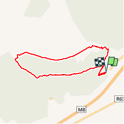
Tour Wandern von 6,4 km verfügbar auf Unbekannt, County Tipperary, The Municipal District of Cahir — Cashel. Diese Tour wird von johnkeating vorgeschlagen.
Beschreibung
Park 50 metres from Mountain Road entrace to Scaragh Wood. Trail follows forest tracks upwards to open mountain. Remains above tree line with excellent views of Cahir, Knockmealdowns, Comeraghs and Slievnamon. Descends via forest track and small paths.
Ort
Land:
Ireland
Region :
Unbekannt
Abteilung/Provinz :
County Tipperary
Kommune :
The Municipal District of Cahir — Cashel
Standort:
Kilcommon
Gehen Sie:(Dec)
Gehen Sie:(UTM)
570883 ; 5803432 (29U) N.
Kommentare
Touren in der Umgebung
![Tour Wandern The Municipal District of Cahir — Cashel - Cahir Scaragh Wood Trail 2 - Photo](https://media.geolcdn.com/t/375/260/ext.jpg?maxdim=2&url=https%3A%2F%2Fservices.sitytrail.com%2FGeolivesWS%2FDownloadMedia.ashx%3FTrailID%3D47228%26Media%3Dimage7.jpg)
![Wandern Wandern](https://static1.geolcdn.com/sitytour/trail-icons/101.png)
Cahir Scaragh Wood Trail 2
Wandern
Sehr leicht
The Municipal District of Cahir — Cashel,
Unbekannt,
County Tipperary,
Ireland
![](/images/other/stat-length.png)
5,5 km | 7,4 km-effort
1h 15min
![](https://static1.geolcdn.com/siteimages/upload/files/16400158638029165_repeat_loop_refresh_sync_direction_icon.png)
Ja
![Tour Wandern The Municipal District of Cahir — Cashel - Cahir Scaragh Wood Trail 1 - Photo](https://media.geolcdn.com/t/375/260/ext.jpg?maxdim=2&url=https%3A%2F%2Fservices.sitytrail.com%2FGeolivesWS%2FDownloadMedia.ashx%3FTrailID%3D47126%26Media%3Dimage2.jpg)
![Wandern Wandern](https://static1.geolcdn.com/sitytour/trail-icons/101.png)
Cahir Scaragh Wood Trail 1
Wandern
Sehr leicht
The Municipal District of Cahir — Cashel,
Unbekannt,
County Tipperary,
Ireland
![](/images/other/stat-length.png)
4,6 km | 5,9 km-effort
1h 0min
![](https://static1.geolcdn.com/siteimages/upload/files/16400158638029165_repeat_loop_refresh_sync_direction_icon.png)
Ja